Back in August, the 4th through the 6th, Todd and I went camping at Poverty Flats, one of my favorite places, with the intention of hiking the South Fork Salmon River canyon from Goat Creek down stream to Poverty Flat. It is about a 7 mile hike, no trail, following the river with super steep terrain on both sides. We were in it for the long haul and had no idea what we were going to see. This canyon is a class 5 kayak section during the spring run off, but by August, the water is way to low to boat but near perfect temperature for wading.
Below picture is what we considered the beginning of the canyon section. Not far from where the road leaves the river.
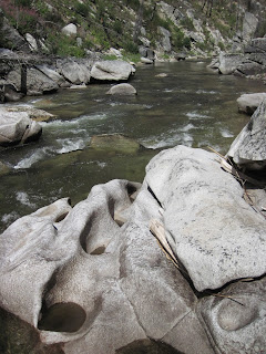
The rock formations in the canyon obviously have been in place for thousands of years as shown from the smoothness of the granite bedrock.
The hill slopes were covered in burnt trees, some still standing, others laying on the ground, while some have floated down stream and were caught up in a gigantic log jam.
Traversing the terrain was difficult as we walked lots of side hilling
and plenty of crisscrossing the river. A sign that the terrain is difficult was the lack of wildlife we saw. There were no squirrels to distract Henry. No deer or elk sign, but plenty of bear sign. Bear paw prints were in the sandy bars and poop all over the grassy areas. Few people must come here for the bears to feel safe from distraction while devouring the salmon. Our path through the canyon followed the same choices as the bear prints, there were few options. At times it was easier to walk
in the river, but anyone who has spent time walking in streams knows
that can be challenging in itself with slippery rocks, uneven footing,
not a straight path, and deep water.
About 5 hours into the hike, we were feeling tired. I looked up the slope for some landmarks to determine how far we have gone and how far we still need to go. At this time we were in the heart of the canyon, the road was at its highest point above the river (over 1000 vertical feet), and we were getting low on food. The sun has been beating down on us all day. Even Henry was starting to get tired. We pushed onward, hoping for relief in terrain or some sign that Poverty Flat was "just around the corner." Anyone who has hiked with me knows I often push a little further to see what is up over the ridge not far ahead, and often the extra effort is futile as there is another ridge and not much of a view. Well, this trip was not much different but instead of looking for a better view, we were looking for a better exit. We turned another corner and saw more canyon walls, deeper water, and no banks to walk on. We finally came upon a large log that spans the river just downstream of a fantastic pour-over into a deep pool below. This would be a fantastic swimming hole.
There were some faint trails leaving up slope from here, either people trail or game trail, but either way, we decided to abort the stream hike and head up slope to the road.This was an adventure in itself. I was so glad to reach pavement. Below is a picture of my feet and legs after the hike up, but before the two mile hike on the road. Luckily we got to the camp well before dark, let the cat out of the truck, pulled out lawn chairs, popped open a beer, and rested, reflecting on the day we just had, and to exhausted to do anything else but take off shoes.
But sometimes, it is well worth the effort. We all need to push a bit to see beauty.
Below is a map of the hike path.


2 comments:
pretty but it looks cooooooooollllld. xxx
It was not cold at all. That is why we did the hike in August...plus there was a hotspring waiting for our sore muscles.
Post a Comment